Friday, September 30, 2011

Bald Mt and Artist's Bluff in Franconia Notch

Bald Mt and Artist's Bluff 
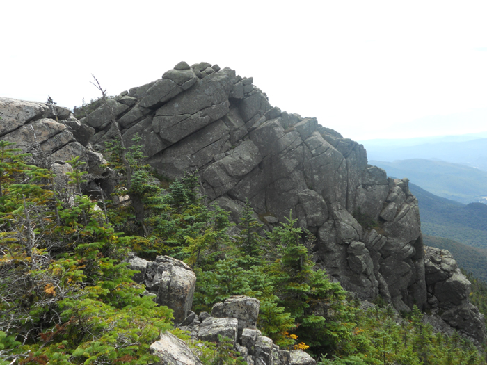
For my Stepson's School Project, he wanted to do a hiking trip where he took the pictures. We checked out the maps and decided to go on the Bald Mt. and Artist's Bluff Adventure. If you want to do the Loop it's about 1 and 1/2 mile. We went back the way we came so it took us a little longer, about 2 miles in all. To get to this adventure, you need to get off Exit 34C in Franconia Notch, there are two different places to park on the side of the road on Route 18. We started near Bald Mt. We hiked up it first which was about .4 from where we started, the hike was easy, there were some steep parts when you get closer to the top. Young children should be very careful. Here is some pictures my stepson took:
This would be the steepest part of the hike up Bald Mt. 
Of course, our dog Stitch had the easiest time getting up there!

 Here we can see some of Franconia Notch and Cannon Mt.

Looking this way, we could see Mittersill Alpine Village and beautiful valley

After we had a snack, we headed back down. We then followed Bald Mt Artist's Bluff Path over to Artist's Bluff. This trail is easy and about .6 miles long. There is also a boulder that you can climb to see a view on the trail which my stepson loved. He loves to climb! I also climbed up it to see the view with Stitch our dog. 
Here is picture my stepson took when we made it over to Artist's Bluff:

You can see the Eagle's Cliff and the Highway 93 

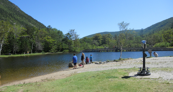
Here is a picture I took of my stepson with a view behind him:
Behind him is Echo Lake and Cannon Mtn. 

After we stayed and look at the views around us, we went back the same way we came up. The adventure took us about three hours to do, and was very enjoyable. If you are up this way, you should check out this really easy and fun loop. Great for children and dogs!
Happy Hiking:)


Tuesday, September 27, 2011

Speechless Wednesday .... First snow on Mt. Washington

 Speechless Wednesday
First snow on top of Mt. Washington this year
Also Mt. Washington Hotel added!


I love seeing the snow just on the peek of the mountains...
so BEAUTIFUL to look at!:)
Happy viewing!

Sunday, September 25, 2011

The Flumes Gorge in Franconia Notch

The Flumes Gorge

Over the years, as a child, I have enjoyed coming here with my family, now as an adult, I take my family here. The Flumes George is located in Franconia Notch, off exit 34A. It is a beautiful place to come visit alone, with your loved one, or with your whole family! You start at the Flume Visitor Center. Inside you get your tickets, they have bathrooms, a place to eat lunch, and a gift shop with some great New Hampshire and White Mountain souvenirs. When you leave the Center, it's like a huge circle. You head to the right and go through a The Flume Covered Bridge. Then you will hit The Flume Gorge which is so beautiful. The Picture up above is close to the start of the Gorge. Here is another picture of me looking back when we were half way through the Gorge:
 It is really amazing to walk through, with walls on both sides and just a narrow walk way. You can see in the picture that there are people bending over looking at the water. There are so places that can be a little scary where you are up high, near the wall with water below. So, hopefully, you are not scared of heights!

There is a lovely waterfall when you reach the end of the Flume Gorge called Avalanche Falls. It is so beautiful. Now The Flume is a natural gorge extending 800 feet at the base of Mount Liberty. I have hiked up Mt. Liberty a few times so they water is cold, fresh mountain water and when it reaches the Flumes it comes down off the Falls into the Gorge. Now, after the Gorge you can continue around the loop, the whole loop is about 2 miles long from the Center. Here you will also see the Liberty cascades and go over the Sentinel Pine Covered Bridge. Walking a little further down you will see the The Pool which is beautiful.After seeing The Pool, you will head back to the Center. This trip around normally takes us about three hours or so to do. If its your first time, it will probably take you longer for you will want to take pictures of everything. 

The Flume Gorge is open daily from May 12th to October 23rd, 2011. Operating hours are 9:00 am  to 5:00 pm. I would say try to get there early and enjoy your whole day! The fall is such a lovely time to go for the trees are so beautiful with their leaves.

Admission is $14 for adults (ages 13+); $11 for children (ages 6-12); children ages 5 and under are admitted free with paid adult.

Now they also have Discovery Pass (Includes Cannon Mountain Aerial Tramway & Flume Gorge): Adults: $26.00, children (ages 6-12): $20.00. So, if you haven't been to either yet, this can be fun to see both, do one in the morning, eat then go enjoy the other in the afternoon!

I hope this has been helpful and that you get to enjoy these wonderful places this fall or next spring!

Friday, September 23, 2011

Mt. Liberty on a beautiful Sunny Day

Mt. Liberty in Franconia Notch

I love spending time hiking in Franconia Notch. I love all the views from every mountain top. When we hiked up Mount Liberty it was a beautiful sunny day. There were prefect views all around us. I had to take pictures though there is nothing like seeing the views with your own eyes. If you are ever up in this part of the White Mountains, you have got to hike up Mt. Liberty. Some people make it a whole day trip and do Mt. Flumes as well. I am hoping to do both at once next year when I stay at the Tent site up near Mt. Liberty. If you want to learn more about the tent site, it was two posts before this one. Mt. Liberty is a 4000footer, 4459 feet. The best Trail to use when hiking up would be the Liberty Springs Trail. The Flume Slide Trail can be very muddy making it very slippery. Be careful when on that trail! You can also reach Mt. Liberty by going across the Franconia Ridge Trail which hits five main mountains in Franconia Notch.
Here are some of my wonderful pictures:
Here is Mt. Liberty 4459 feet 
Hiking this mountain in Sept. was great for there are few hikers out, 
so the mountain almost feels like its yours.

 My friend up the trail with my dog Stitch. This was also
stitch's first hike up a 4000 footer and he loved it!
Stitch and I look every small from where my friend took this picture. 
We are near the very top of Mt. Liberty and could see all the way around. It was awesome!

 This is a picture of Mt. Flume from Mt. Liberty
This picture is of Mt. Cannon, you can see the clouds rolling over it.

Here is where you can hop on the Franconia Ridge Trail and head over to 
Little Haystack, Mt. Lincoln, Mt. Lafayette!

Over all I loved this hike and hoping to do it again next year but this time stay over night up in the mountains!
Happy Hiking!

PS...On This hike we made friends with a guy from Conn. He drove up just to do some hiking, staying and then leaving the next day.  He hiked all over and seemed to know everything about the Whites. He talked about his ex-wife, his new girlfriend he meet on a Hiking dating site, his dog he had for five years, a cat that was really not his, but he ended up paying money to put to sleep, that he was the youngest, had older sisters, and he enjoyed a beer after a hike..the only thing I never got was his name! lol ...Thanks for hanging with us on our hike, it was great meeting you (No Name) :) 
ALWAYS ENJOY MEETING NEW HIKERS ALONG ANY OF MY HIKES!:)

Wednesday, September 21, 2011

Speechless Wednesday Once again!


Speechless Wednesday
A View From The Ammonoosuc Ravine Trail

I love that I could see the Valley of Crawford Notch and
the Mt. Washington Hotel :)
Happy Hiking!

Monday, September 19, 2011

Mt. Liberty (Liberty Springs Tentsite) Franconia Notch

Liberty Springs Tentsite in Franconia Notch

We went up to Mt. Liberty little over a week ago and came across the Liberty Springs Tentsite,
on our way up Liberty Springs Trail. I enjoyed seeing the tentsite and now hoping to have my
first overnight next year with my friend at this site. It was great and only $8.00 per night during the season for each person. They have a Site Watcher, a place to get fresh spring water and different sites. When staying here they have an Outhouse for use. There are Group and singles camp sites. 
I really hope that I do get to stay over night next year!
Here are some pics of the tentsite!

You will see the Tentsite Watcher first when you come up the trail

Here are the Tentsites and where they are located

This is where you can get fresh water to drink and 
fill up on the way to Mt. Liberty

Here are the Group tentsites, the singles are in the back

Great place to stay and wake up to continue on an Outdoors Adventure!:)

Friday, September 16, 2011

Hiking Mt Washington...Part 3

Mt Washington...Part 3

After hanging out around the Lakes of the Clouds Hut, we started up the Crawford Path, which is the 
oldest used trail in America that is kept up. We had about one mile until we reaches the summit. The wind had picked up and the clouds were getting closer as we went forward. The temperature went down fast and we were starting to get cold. Here are a few pics of going up the trail...

Here we are starting the trail and you can see the summit of Mt. Washington from the Lakes.

Here is when we were very close  to the top of the summit looking back at the Lakes and the Hut.

When reaching the top of Mt. Washington, it was cold, windy and the clouds were all around us. We couldn't see any views for awhile until there were breaks in the clouds. But, We went into the Tip Top House, and got a picture with the sign that states you are at the Summit of Mt. Washington. 
Here are a few pics...

 Here is the Tip Top House, It was used back in the day for hikers to rest the night when reaching the
summit. Now, visitors can go inside a look around. This was very interesting and a must see for those that
love the history of the White Mountains.

This is the marker at the highest point on the summit of Mt. Washington

Yep, I was trying to smile, but it was so windy and cold. I also wanted
something to eat, which we did after in the cafe. When you travel
up to the summit, you have to get your picture with this sign!

I thought this sign was very interesting...I love history of the White Mountains

Inga- This cat was my idol, she lived on top of Mt. Washington for Years.
Now a new cat Marty lives on top!

There is my hike up Mount. Washington :)
Can't wait to do it again next year!
Happy Hiking!

Wednesday, September 14, 2011

Speechless Wednesday! Mt. Washington -Part 2

Speechless Wednesday! Mt. Washington -Part 2
The Lakes of the Clouds
 
 There are two beautiful lakes that are near Mt. Washington.
They are on each side of the trail called Crawford Path (which
is also the oldest maintained footpath in America). 
Here they are:

Lake One (Right side on Trail)

Lake 2 (Left side on Trail)

After these wonderful views we headed up to Mt. Washington...
Happy Hiking

Sunday, September 11, 2011

9-11 Hiking Mt. Washington...Part 1

Today is 9-11th and it was the day we
picked to hike up Mt. Washington.
(the view from Ammonoosuc Ravine Trail)

We started our hike up the mountain a little later then we wanted to start. So instead of parking below in the hiking parking. We went up to the Cog Railway and started there, which has a small 0.3 mile trail that connects to the Ammonoosuc Ravine Trail. To park at the Cog for hiking it cost $5.00. You can park at the low parking lot and walk up to the trail. I would have to say that I enjoyed the pool, waterfalls and cascades along this trail. Here are some of my pictures of the hike up to our first stop, which was the Lake of the Clouds...

When we connected onto the Ammonoosuc Ravine Tr. this is the sign we saw..
If you want to stay at the Lake of the Clouds, you need to make a 
reservation so you can have a spot!

They had a Sign of a person who lost their life hiking
up this Mountain. There has been 145 people who have lost their
lives in these parts! Can read about each one at the top of Mt. Washington!

The Gem Pool:)

The Gorge (80 yards from the Trail)

A beautiful sight as I crossed over this river following the trail

Heading up 2.1 miles from the marker, we can across The Lake of the Clouds Hut. I love this hut, but sadly you couldn't really go inside and enjoy it for they were cleaning. The hut was closed but you could still get water and use the restrooms. 
You can see by this picture all the mats were outside being washed. Good to know that the
place is always being well kept up for all the hikers that pass through here!

This is Mt. Monroe and as we were at the Hut, we heard a song called "Taps"
and saw them lowering the flag for 9-11.

This is part one...lots of pics here...and more pics to come of my trip up Mt. Washington on 9-11....

Wednesday, September 7, 2011

Speechless Wednesday

Speechless Wednesday - Mt. Washington 
seen when passing through Crawford Notch


Here is the Mt. Washington Hotel with Mt. Washington in the
background. Wish I could wake up to a view like that
every morning! Amazing!

Tuesday, September 6, 2011

Mt. Washington State Park

Mt. Washington State Park
Out of all the places in the White Mountain Regain, this is my favorite to explore. The trails are so wonderful travel on and the people you meet along with way, are so friendly and helpful. I am hoping to hike Mt. Washington before fall really sets in. I plan on taking the same route that I did back in 2008. Hiking up the Ammonoosuc Ravine Trail to the Lakes of the Clouds. Then take Crawford Path to the Summit for the beautiful mountain (Mt. Washington). Last time it was foggy so I never got to see any views, I was lucky enough to find the building itself! I would like to be able to hike a trail back down that I never got to last time, because the weather turned and we couldn't hike down. The trail I want to take is Jewell Trail, it is to lead me back down to the Cog Railway where the trails start. When I hike this mountain this week or the next I plan on posting my pics and my adventure story up here soon after. 
 I am hoping that one day, I can stay up at the Lake of the Clouds AMC Hut and wake up to the sunrise. I bet that is so beautiful to see the Sun rise above the Lakes up there. Plus I have always wanted to hike Mt. Monroe as well...wonder if I could do both Mountains on the same day? I bet I could. It's only .3 miles from the AMC Hut. There are so many places to see beautiful views once you are up in the Presidential Range that it will be very tough to come back down again. I feel like I am in a whole new world when I am up there. Soon, I hope to be able to stay up here for some time and see as much as I can before I have to come back down again! Here's hoping!

Sunday, September 4, 2011

Expanding my Hiking Blog

Expanding my hiking blog

It seems that my blog is becoming more popular so be reach out to more
people I am now on Facebook. You can find me under Ariel Snow, I have hiking pictures up
of the Great White Mountains of New Hampshire!
You can also "like" my fan page...just go here:
http://www.facebook.com/pages/Blogger/151520398269089
 
I need 25 people to make it a Fan Page with a URL
so if you can please help me out!
and again..Thanks for Supporting 
The Adventure Hiker Speaks
 
Happy Hiking:)

Thursday, September 1, 2011

Willey House Historic Site

Willey House Historic Site
in Crawford Notch

My stepson and I went to explore this wonderful Historical Site two weeks ago. This place was where the Willey's House once stood and the story of the Willey family is pretty sad. It was a tragedy where all nine people living in the house lost their lives to rock slide. When the rock slide happened, all nine people left the house, Sam Willey, his wife, kids and two workers. The house never was touched by the slide, for a boulder stopped the slide from hitting it. The Willey family sadly didn't make it and were all found dead in the rock slide. This is the site of where the house which was also the Willey's family in stood year ago. Here at the site, there is a lovely pond to feed the ducks at. Children under 12 can fish here, limit being two. Here are some pics...

Here is the Lake (Top pic) and the Gift/Ice Cream Shop (lower pic)


There are also some wonderful trails for those that want to explore the area around. We took the Sam Willey Trail because it was named after the husband who lost his life in the rock slide. This is at the start of the trail. 
 On this Sam Willey's Trail you have to watch for bears. There is also a
sign to be careful for it's bear country. There were also muddy swamp places
where moose love to hang out. I have been on a trail with moose, always 
move slowly, and stay your distance. They can be very dangerous. 

At the Willey House you can hike two wonderful mountains, all you have to decide
is which way you want to go. 

We went up to the Kedron Falls which is the way you would go to Mt. Willey. It is around 1.3 miles up, the Kedron Brook Trail. It was so beautiful up there. 
Here is the sign to the start of the trail. There were lots of edges which
made me nervous with my dog and stepson, so I wouldn't recommend for
small children under 10.
Here was the view and Flume:

After we had a snack and enjoyed the area, we traveled back down where 
we went to get some yummy ice cream at the gift shop.
Great place to visit when you are up in Crawford Notch!:)
Related Posts Plugin for WordPress, Blogger...