Showing posts with label Trail Report. Show all posts

Wednesday, May 16, 2012

Trail Report: Ripley Falls - Crawford Notch

This trail report leaves off of my last blog on Monday with the Frankenstein Cliffs, we headed down the path to the a sign that was on The Arethusa Ripley Falls Trail and we had two ways to go...Arethusa Falls or Ripley Falls. I had seen Arethusa Falls last year so I wanted to head to Ripley Falls. From the sign it was 1.2 miles over to Ripley Falls. The trail was mostly flat, about .7 miles of the way ,but then it was a descend to get to Ripley Falls. Now Ripley Falls is the second largest waterfall in NH (approx. 100 ft). The fall was beautiful and worth the hike over to see it.
Here are my pictures of the Falls:

The sign to help you decide which way to hike

The top of Ripley Falls when coming down the trail

Ripley Falls from below near the pool
After the falls you can go back up the trail over to Arethusa Falls, and that will be 2.3 miles over, or you can take the Ripley Falls Trail and head over to Route 302 and walk the road. We decided to walk the road back to our car, which was 2.5 miles. Over all great hike!

The tracks you cross when going to the parking lot
Enjoy your hike in the White Mountains...Happy hiking!:)

Friday, April 27, 2012

Trail Report : Mt. Willard and the cascades

Last Thursday and Friday I stayed at the AMC Highland center in Crawford Notch. It was a wonderful stay and I got to go out on some of the trails. Two trails I explored were Mt. Willard Trail and Avalon Trail. If you are looking to hike these trails, they are mostly cleared. There are a few snow patches, and a little ice. The stream to over Mt. Willard Trail is over flowing due to melting so the trail is a little hard to find at the bottom. The view at the top of Mt. Willard is stunning as always. I enjoyed seeing both Beeches and Pearl Cascade, for they are so lovely with the water flowing so rapidly.
Here are some pics I took of these adventures. These places are great also to take children too. The hikes are fun and not difficult. Happy Hiking:)

 This is Beeches Cascade which is on the cascade loop.
The loop is about a mile all the way around.
Great trail for children to explore.

 This is Pearl cascade which is on the cascade loop.

This is the view from top of Mt. Willard. You can see the Valley and mountains on both sides. It was a great day for a hike up that morning. We started around 9:00 am and made it to the top by 11:00 am with a fw small stops along the way for the kids to have a break. The weather was a little chilly on top but all was needed was a windbreaker. Great place to have lunch, which we did and enjoyed the view. The trail is 1.6 miles to the top. Great for children to hike up!

Sunday, February 12, 2012

Trail Report: Falling Waters Trail

This past Saturday, my stepson, dog Stitch and I decided it would be fun to explore more of Franconia Notch. the snow in thick and the trails are packed down this time of year. We parked at the Lafayette Place and started our hike up the trail. It's .2 miles to the bridge where the trail splits in to ways. My stepson loves waterfalls, so we decided to take the Falling Waters Trail.
Now, I don't hike that much in winter, but I was so happy that I hiked on Saturday. It as lightly snowing and the temp was about 30 degrees. I never felt cold and I loved seeing the snow fall. It was so beautiful. The trail was so well packed and easy to follow. We hiked up to Cloudland Falls. Sadly, I forgot my camera and my cellphone batteries were dying on me. I got a picture though of Stairs Falls though. I have to say that out of all three falls, I am happy I got a picture of this waterfall, or I loved how the ice formed a circle (like a bubble) around the fall. The hike itself was about two and half hours. 1.4 miles one way to see all three Falls. Right now though you can't really see Swiftwater Falls for it's hiding under the ice and snow. Both Stairs and Cloudland Falls you can see. Here is a pic of Stairs Falls:

 Picture taken from the trail

I got closer to take this picture. I love how the ice formed around the Falls.

If you are interested in doing so hiking this winter, I would say start over at
Franconia Notch. The trails are packed down and the parking is clear.
Thanks for stopping by! Happy Hiking:)

Saturday, January 28, 2012

Trail Report: Franconia Notch Kinsman Falls

Today is a beautiful Winter's day. The temp outside is 35 to 37 degrees and everyone is out, enjoying some winter hiking. The trail Cascade Brook Trail is hike-able up to the Kinsman Falls, for then after you have to cross the river which is not really frozen over all the way. There were footprints up to that point, but no one has gone any further up the trail. I had my ten year old stepson and dog with me so I didn't want to chance anyone falling in the icy cold water. The parking lot to the Basin and trail is well taken care of and there were many people out checking out the area. The Basin was beautiful as always and the water flowing. If you want to hike in this area you can't go to far but it is still beautiful and great to see during the winter months. Can go about .7 miles up the trail. Here are some of the pictures I took today on my small adventure in Franconia Notch.
 Half way up, we came across this view,
as you can see the river is not all frozen.

 I loved this frozen Kinsman Falls

and we had to stop at the Basin, I just love this spot. It is always
beautiful no matter what season!

Happy Winter Hiking:)

Monday, December 26, 2011

Crawford Notch Hiking Part 2

Heading up to Bugle Cliff after Elephant head. We went another .6 miles up the main trail called Webster/Jackson Trail and came across a sign that had a little arrow, with a saying on the side about a Cliff View. I knew this had to be Bugle Cliff so we went up the side to check it out. It was so worth the hike up! Amazing Views and so beautiful in the winter months:
This is the sign to Bugle Cliff

Can see the Route302 and mountains

This was such a wonderful view of the mountains

Look in the back and you can see the Washington Hotel with mountains
This hike all together was about 2 miles all together to see both Elephant Head and Bugle Cliff. It was a great winter hike and would recommend it:) Also great for children and dogs as well!

Monday, December 19, 2011

Winter Hiking in Crawford Notch Part 1


Elephant Head
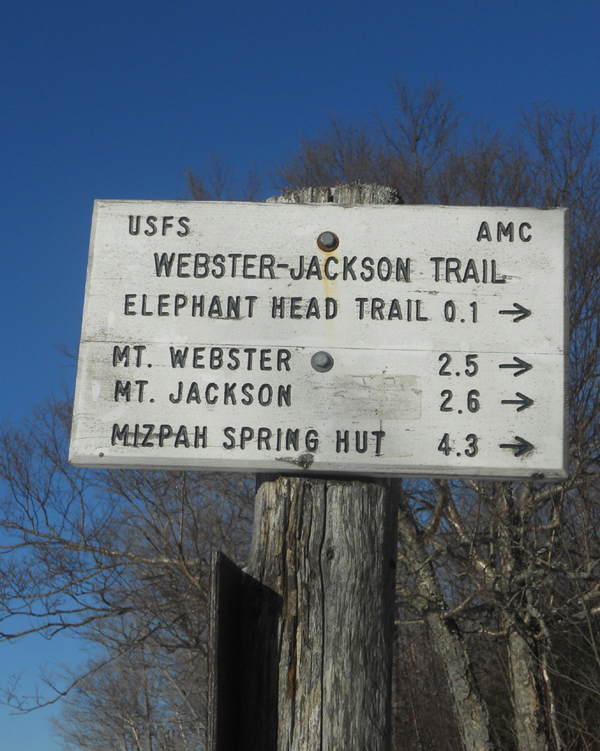
This was a great day for a hike in the White Mountains. The trail that was taken this hiking trip was Webster-Jackson Trail, for it leads to both mountains. The weather was 20 degrees. I decided to take my stepson up the trail to Elephant Head and Beagle Cliff. Now Elephant Head is not far the start of the trail and gives some great views of Crawford Notch. There is parking across the road near the Gateway of the Notch or you can also park also the Saco Lake. I have also parked near the Crawford Notch Depot, there is also a gift shop there if you are a site seeing and want to pick up a item of Crawford Notch and the White Mountains.


There is a sign that you will see when you get to the entrance of the trail. 
This sign is right near the road so you can't miss it. 

The trail was well packed by other hikers, but had some
ice patches in many places.

The sign for Elephant head is very large so you can't miss
the trail that takes you there. It's about .2 miles
from the main trail. Worth seeing!

The views from Elephant Head


We also found this sign:
Does anyone know anything about it?

After we saw the views from Elephant Head, we hiked back and 
went up the main trail some more to Bugle Cliff
which had some beautiful views as well and
I will be posting them soon!:)
Happy Hiking


Related Posts Plugin for WordPress, Blogger...