Wednesday, May 30, 2012

Trail Report : Davis Path up to Mt. Crawford

I have always wanted to hike up Mt. Crawford. The hiking trail to take is Davis Path and you can reach the trail outside of Crawford Notch on route 302 heading to Bartlett. There is parking next to Saco River and you will walk down a dirt road until you reach the Bemis Suspension Bridge. There are homes on the other side of the bridge. You will walk on the path past them until you get to a sign that states that you are in the Presidential Range - Dry River Wilderness. If you are hoping to take shelter at the Resolution Shelter, you will be out of luck for it's closed. At least  it is for now, there is a sign at the beginning stating this.

The sign on the trail
There is also a sign that talks about the Davis Path. It was Nathaniel Davis who constructed the trail to Mt. Washington back in 1844. The trail itself is 14.4 miles to the top of Mt. Washington and pass many amazing mountains and views on your way up. We went as far as Mt. Crawford which is the first mountain you would come across on the path. It is 2.5 miles up Davis Path and has some amazing views. Plus there are a few view pints along the way up to that mountain which is 3119'.
Here are a few pictures I took as I hiked up to Mt. Crawford:

Mt. Wildcat in the distance

you can see the Notchland Inn and Valley
When you get closer to Mt. Crawford you will be following markers on the boulders. I found some of the markers tricky and we did go off the path once. It took us a little time I back track so follow the markers closely. They are white and blue lines the rocks, and some are faded.

The sign to look for...

A beautiful view from on top of Mt. Crawford

A great view

Another lovely view
The hike took us about three and half hours to do and I enjoyed every bit of it. I hope to next time get to hike over to Mt. Resolution and Stairs Mt.

Happy Hiking:)

Wednesday, May 23, 2012

Great photo spot of Mt Washington in Crawford Notch

If you have traveled through Crawford Notch for site seeing or hiking, you might have missed this photo opportunity at the Mt Washington Viewpoint. It's right off the side of Route 302, not far from the parking lot to Arethusa Falls.
See, we had missed the entrance to the parking and needed to turn around, so we found the next place to make the turn. Then a saw a beautiful sight..Mt. Washington! There was already another car with someone taking a picture. I got out and snapped a shot. I love how it's just the top of Mt. Washington, a different angle then what you see from the Mt. Washington Hotel Viewpoint up the road.
Here is the picture:

The Top of Mt. Washington

Wednesday, May 16, 2012

Trail Report: Ripley Falls - Crawford Notch

This trail report leaves off of my last blog on Monday with the Frankenstein Cliffs, we headed down the path to the a sign that was on The Arethusa Ripley Falls Trail and we had two ways to go...Arethusa Falls or Ripley Falls. I had seen Arethusa Falls last year so I wanted to head to Ripley Falls. From the sign it was 1.2 miles over to Ripley Falls. The trail was mostly flat, about .7 miles of the way ,but then it was a descend to get to Ripley Falls. Now Ripley Falls is the second largest waterfall in NH (approx. 100 ft). The fall was beautiful and worth the hike over to see it.
Here are my pictures of the Falls:

The sign to help you decide which way to hike

The top of Ripley Falls when coming down the trail

Ripley Falls from below near the pool
After the falls you can go back up the trail over to Arethusa Falls, and that will be 2.3 miles over, or you can take the Ripley Falls Trail and head over to Route 302 and walk the road. We decided to walk the road back to our car, which was 2.5 miles. Over all great hike!

The tracks you cross when going to the parking lot
Enjoy your hike in the White Mountains...Happy hiking!:)

Monday, May 14, 2012

Trail Report: Frankenstien Cliffs - Crawford Notch

Yesterday was Mother's Day and so I decided that for the day, I wanted to hike up Frankenstein Cliffs. I have always been very curious about the cliffs and why they were called Frankenstein Cliffs in the first place. It was named after an artist. There is a sign below in the valley that is on the Frankenstein Trestle. I have been to the parking area before for it's the same place you would park if you were hiking up to see the Arethusa Falls. This time we took the trail to the left instead of the trail up the road to the right.
This trail is .6 miles over to the Frankenstein Trestle. You cross under the tracks and then hike up the cliffs. The trail to the over cliffs is .7 miles and in some parts very steep. The cliffs you are hiking near are beautiful and very high. Once you hike up a ways you get to relax at the lower cliffs. There are some beautiful views of the Crawford Notch valley and mountains. The awesome part is that you can see the top of Arethusa Falls from the lower cliffs.
Then we headed up the trail to the Falcon Cliffs, but it was another .7 miles in and we decided to pass by the trail. If you do take that trail, it is said that you will have a great view of Mt. Washington. We headed to the top pf Frankenstein Cliffs where we were to see Mt. Washington and you can see it if you stand on a rock a little ways from the sign. I was a bit disappointed because the trees are grown so you can't see the view anymore. That trail was .8 miles and the elevation was 2531'.
Here are some pictures of the views and signs on the trail.
 The sign to follow to the Cliffs

 Frankenstein Trestle

 On the Tracks

The Cliffs when hiking up

 The view from lower cliffs

 The sign on top of Frankenstein Cliffs with no view

Next post will be Ripley Falls
Happy Hiking

Sunday, May 6, 2012

Trail Report: Bridal Veil Falls - Coppermine Trail

When hiking up to Bridal Veil Falls, you need to park at the beginning of Coppermine Rd as seem in this picture. There are many signs after saying you can't park for it's a private road.
This is the sign where you need to park. 
You will hike up the road where .4 miles to the start of Coppermine Trail which is 2.1 miles. The Trail is very open and easy to hike up. The interesting part of the trail is where the trail meets the brook. If you walk up the brook about .25 miles, you will see a plaque on a boulder. 

This is where the plaque is located

The plaque itself, up close
It is said that the plaque was put on the boulder by Betty Davis. She had meet Arthur on the trail when she was lost. They feel in love and married. Years later after he mysterious death, where Betty was put on trail for,  a plaque showed up on the boulder. They say if you get lost in these woods, you might find yourself being found by "the keeper of stray ladies".

There is a shelter at the top near the falls for those that stay the night and want to be out of the wind. There is also a fire pit near the shelter as well.

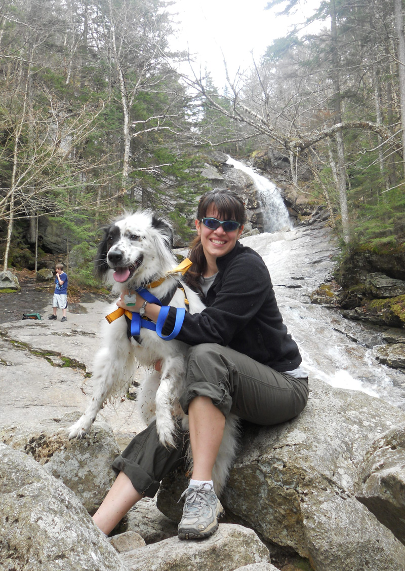
Hanging out with my wonderful dog Stitch at the Falls

This is the Bridal Veil Falls

 You can hike to the very top where you can see the Falls and the pool it leads into, then it falls the rest of the way down the to the shelter below. My husband and stepson hiked to the top of the falls while I stayed near the middle with Stitch. It seemed with it being spring the water was higher and moving faster, and I felt the dog would be safer below. Also there was a family with small children who didn't go to the top. It wasn't safe.

My stepson at the top of the Falls


It was a great hike overall. The hike itself was 5 miles and was an easy hike. If you are around the Franconia area and want to see the lovely Bridal Veils Falls, then travel down Route 116 to Coppermine Rd.
 Happy Hiking!
Related Posts Plugin for WordPress, Blogger...